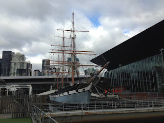
Yarra River or Yarra Yarra.
The lower parts of the river are at a place where the city of Melbourne was founded in 1835 and today the Grand Melbourne has an impact on the landscape in the lower reaches of the river. From its source, it flows over 242 kilometers (150 miles) to the west through the Yarra Valley, where out of the plains, paving its way through the Grand Melbourne before flowing into Hobsons Bay in the northern part of Port Phillip.
The river was the main source of food and meeting place for indigenous Australians from prehistoric times. Shortly after the arrival of European settlers clearing land vurundzheri forced the tribe to move to the neighboring area away from the river. Birrarung original name, the language vurundzheri was mistranslated from another term vurundzheri on Boonwurrung language; Yarro-Yarro, which means "everything flows."
The river has been used primarily for the development of agriculture by early European settlers. The river landscape has changed dramatically since 1835. The course of the river is gradually broken and it has expanded in some places. The first bridge was built Princes Bridge which would make better the passage of ships. Since the time of the Victorian gold rush Bend Tunnel in Warrandyte was created and reclaimed large and small peninsulas above the tunnels in Warburton. We expand and build dams on the Upper Reservoir helping to protect Melbourne from major floods. The upper reaches of the catchment area are also affected by logging. Industrialization ultimately led to the destruction of wetlands at the confluence of the Yarra and Maribyrnong Rivers in the area around the island of Kood in West Melbourne.
Today, Swanson and Appleton's docks handle container shipping port in Melbourne, which is the busiest on the continent. In the urban area of the river, which is not available for the majority of personal watercraft, it is more widely used for transport and pleasure boats (including kayaking, canoeing, rowing, and swimming) . However recreational use of the river is threatened because of the high level of pollution in its lower portions. The upper reaches of the river are relatively clean.
Река Ярра или Ярра Ярра.
Нижние участки реки находятся на месте, где был заложен город Мельбурн в 1835 году и сегодня Большой Мельбурн оказывает влияние на ландшафт в нижнем течении реки. От своего источника она течет на протяжении 242 километров (150 миль) к западу через долину Ярра, откуда выходит на равнины, прокладывая свой путь через Большой Мельбурн, прежде чем впадает в залив Hobsons в северной части Порт-Филлипа.
Река была основным источником пропитания и местом встречи для коренных австралийцев с доисторических времен. Вскоре после прибытия европейских поселенцев расчистки земель вынудили племя вурунджери переместиться на соседние территории далеко от реки. Первоначальное название Birrarung, на языке вурунджери, было неправильно переведено из другого термина вурунджери на языке Boonwurrung; Ярро-Ярро, что означает "все течет".
Река использовалась главным образом для развития сельского хозяйства ранних европейских поселенцев. Ландшафт реки резко изменился с 1835 года. Курс реки постепенно нарушался и она расширилась в некоторых местах. Первым был построен мост Princes Bridge для того что бы обкеспечить проход кораблей. Начиная с времен викторианской золотой лихорадки были созданы туннель Bend в Warrandyte и намыты большой и маленький полуостровы Туннели выше Уорбертон. Расширялись и строились плотины в Верхнем водохранилище помогая защитить Мельбурн от крупных наводнений. Верховья водосборного бассейна также затронуты рубками. Индустриализация в конечном счете, привела к разрушению болотистых земель при слиянии рек Ярра и Maribyrnong в районе вокруг острова Куд в West Melbourne.
Сегодня в доках Swanson и Appleton осуществляются контейнерные перевозки в порт Мельбурн, который является самым загруженным на континенте. В городской черте реки, которая недоступна для большей части гидроциклов, она более широко используется для транспорта и прогулочных судов (в том числе катания на байдарках, каноэ, гребли и плавания).Однако рекреационное использование реки находится под угрозой из-за высокого уровня загрязнения в ее нижнем участках. Верховья реки остаются относительно чистыми.


